Monday, August 12, 2013 Cody, Wyoming to Custer, South Dakota
After another great breakfast at the Southfork B&B, we left Cody to head for Custer, South Dakota. Steve had tried to make our drive days relatively short, but this one was going to run 7 - 8 hours, not including stops.
The scenery leaving Cody is almost flat with some rolling hills. Farming is with irrigation. In the distance you can see mountains to the east. Occasionally you see a strange outcropping of stone.
We're headed for the Big Horn Mountains, about halfway between Yellowstone and Mt. Rushmore. As we approach, the scenery changes. We start seeing plateaus and rocks similar to those before Cody.
We're having connection problems, and it's late, so I'll finish this tomorrow. I'm back.
We travel through the Big Horn Mountains, which have suffered forest fires, but not as badly as Yellowstone. The Big Horn Mountains are not as heavily forested as Yellowstone, which helps limit the spread of fires. As we're driving through, a report comes on NPR (we're listening on satellite radio) about how forest fires are bigger this year than usual. The Big Horn Mountians are also suffering from the pine beetle, which kills the trees. If the dead tree is just a skeleton, it was fire. If the needles are still there, it was the pine beetle.
We leave the mountains behind for the gentle rolling hills of eastern Wyoming. This is coal country. We didn't see any open pit mines, but we saw miles of coal trains.
We leave I-90 to head for Custer, South Dakota. As we near South Dakota, the landscape changes again to pine forested mountains. We've been driving all day, but looking at times and events, it looks like we might be able to see Mt. Rushmore tonight. They light it in the evening and we've heard that we should see it at night. Steve has reserved rooms for us at the Rocket Motel in Custer. I tease him about not being able to pass up the name, but he assures me it was well rated on tripadvisor, but we have to check in by six. So we drive to the hotel, where a sign says "Rockin' with Jesus at the Rocket Motel." The motel was built in the 50's and has been kept up and recently refurbished, using a 50's theme. It's well done. Bathroom is brand new with black and white tile. I'll try to take a picture of the outside.
Anyway, we check in and head for Mt. Rushmore. We pass the large Crazy Horse statue that's still in progress. The face is done and you can see the top of his outstretched arm. We don't go into that park, as we want to get to Mt. Rushmore and have dinner before the lighting ceremony at 8 pm.
We miss the turnoff for Mt. Rushmore. I thought we should turn at a certain point, but if there was a sign, we missed it. (This was irritating, as there were many signs for Crazy Horse, which is a private site, but few if any for Mt. Rushmore.) After checking 3 guide books for maps, we stumble into Mt. Rushmore. You can see Mt. Rushmore from the public highway, but if you want to get closer, you pay an $11 parking fee. A private entity, which supports Mt. Rushmore, built the parking garages which were needed and that's how they are payed for.
Mt. Rushmore is well done. It has a stately feeling to it while remaining open. The sculpture is visible from almost everywhere. There are two visitor centers, a short hike around the property, the sculpter's studio, gift shops and a restaurant. An ampitheater and viewing terrace are situated to view the sculpture. Here's our view at supper.
On our way to the viewing terrace, we have our only wildlife encounter of the day, a mountain goat.
Here's Mt. Rushmore, up close.
And a sunset picture.
They started the presentation at 8. The ranger introduced a movie, more like a slide show, that told about how the monument came to be and the presidents that were chosen. Originally, the state historian for South Dakota wanted sculptures of men of the west created to attract tourists and teach about South Dakota history. He didn't find much support for the idea until he talked to one of the senators from the state, who helped promote the idea and suggested a sculpter be found to help solidify the project. Gutzon Borglum was carving Robert E. Lees face at Stone Mountain, Georgia and was asked to consider the project. He agreed and immediately changed the project from regional to national heros. The project still had many road blocks and it wasn't until President Calvin Coolidge spent the summer at nearby Custer State Park that the project took off. They persuaded President Collidge to give a speech at the dedication of the project and he surprised them by promising federal funding. It was still a struggle for funding as the project ran from 1927 to 1941, during the depression. 400 people worked on the sculpture over the years.
Gutzon Borglum also chose which presidents he'd carve - Washington, the father of the country, Jefferson, for expansion (Louisiana Purchase), Lincoln for preserving the union, and Theodore Roosevelt for progress. Roosevelt was a close friend of Gutzon Borglum.
At then end of the movie, America the Beautifle was sung. The lights were turned on.
My first thought was "When are they going to turn on the rest of the lights?" Then, "Steve would have done it better."
But the best part of the evening was coming. The ranger asked us all to sing the national anthem and then he would invite members of the military, both past and present, to help lower the flag. We sang the anthem and the ranger invited the military down front. No one left and every one clapped as over 100 service men and women made their way to the stage. A standing ovation! After the flag was lowered and properly folded, the ranger asked each person to identify themselves and their branch of service. The crowd stayed standing and gave another round of applause after the last person was introduced.
As a member of the generation that saw Vietnam and the treatment our veterans received, I was moved by the crowd's response to our military men and women. It was amazing.
Monday, August 12, 2013
Sunday, August 11, 2013
I went to bed early Saturday and didn't blog, so I'll bring you up to date.
Saturday, we left Canyon Lodge, Yellowstone and started on our way to Cody, Wyoming. Steve was a bit excited, as our exit route would take us back through Hayden valley, where we had seen lots of buffalo 2 days ago. He wasn't disappointed.
This one decided to climb up on the roadway, stopping traffic.
What do you do when a buffalo decides to walk down the highway? Follow him.
This was taken through the windshield, which is why there is some glare. We followed him until he decided to walk beside the road instead of on it. Then we came upon valley after valley of buffalo. This is one of my favorite pictures.
A few feet away, I was able to set up this picture for someone to take for us. I think it's a great shot.
At least it shows we were near some buffalo!
The buffalo had traffic backed up forever that morning, as they kept deciding to cross the road. The rangers try to keep traffic moving, but when the buffalo is in the middle of the road, there's not much anyone can do.
We decided to stop at the mud volcano, as we'd passed it by twice. This mud pot used to be a mud geyser that shot mud up into the air until some earthquakes in the 1970's changed things underground. This is one of the pools at that site.
The bubbles I hope you can see indicate that the water is in fact boiling. In this next pool, the water is just steaming.
If you notice the green hillside beyond the pool, that used to be covered in pine trees. They all died after the 1970's earthquakes, not because of the quakes, but because the ground temperature had been raised to 200 degrees!
We had some more excitement at this stop. The buffalo decided to invade the parking lot. I was back at the car and managed to get this shot.
A lot of the art was very good, but expected subject matter. There must have been 10 different paintings of the lower falls of the Grand Canyon of Yellowstone. But there were several unique pieces. Steve and I each took a picture of this piece. The plaque beside it said something along the lines of ".. a traditional subject with a modern twist."
I went to bed early Saturday and didn't blog, so I'll bring you up to date.
Saturday, we left Canyon Lodge, Yellowstone and started on our way to Cody, Wyoming. Steve was a bit excited, as our exit route would take us back through Hayden valley, where we had seen lots of buffalo 2 days ago. He wasn't disappointed.
This one decided to climb up on the roadway, stopping traffic.
What do you do when a buffalo decides to walk down the highway? Follow him.
This was taken through the windshield, which is why there is some glare. We followed him until he decided to walk beside the road instead of on it. Then we came upon valley after valley of buffalo. This is one of my favorite pictures.
A few feet away, I was able to set up this picture for someone to take for us. I think it's a great shot.
At least it shows we were near some buffalo!
The buffalo had traffic backed up forever that morning, as they kept deciding to cross the road. The rangers try to keep traffic moving, but when the buffalo is in the middle of the road, there's not much anyone can do.
We decided to stop at the mud volcano, as we'd passed it by twice. This mud pot used to be a mud geyser that shot mud up into the air until some earthquakes in the 1970's changed things underground. This is one of the pools at that site.
The bubbles I hope you can see indicate that the water is in fact boiling. In this next pool, the water is just steaming.
If you notice the green hillside beyond the pool, that used to be covered in pine trees. They all died after the 1970's earthquakes, not because of the quakes, but because the ground temperature had been raised to 200 degrees!
We had some more excitement at this stop. The buffalo decided to invade the parking lot. I was back at the car and managed to get this shot.
Steve managed to get this one. The buffalo is actually standing on an area they don't want people on because of the danger.
People are always ignoring the danger signs, why not buffalo? I think he's giving Steve the evil eye.
We finally left the buffalo country and turned off onto the road leading out of the park. It was lunchtime, so we stopped at the general store at that intersection and pick up some lunch to picnic with. Picnic areas are plentiful in the park and don't seem to get a lot of traffic, so we were sure one of the first two areas on the map would work for us. We were wrong.
Almost immediately after leaving the general store, we ran into burned forest, which extended for miles.
Much of this had to be recent fire, as trees hadn't started growing back or were less that a foot tall. It's so sad to see. Maybe between the volcano, the earthquakes and the forest fire, Mother Nature is trying to tell us something.
We finally got back into mountains with trees on them and found a nice picnic area for lunch. The picnic areas are quite nice, all things considered. Tables and outhouses, which are equipped with toilet paper and hand sanitizer. About as good as you can get if you don't have flush toilets. We had a nice peaceful lunch under the tall pines and then got back on the road. We finally left Yellowstone and the scenery changed. We were still in a mountainous region, but it was dry, with little green. It looked more like what we are used to seeing in Arizona.
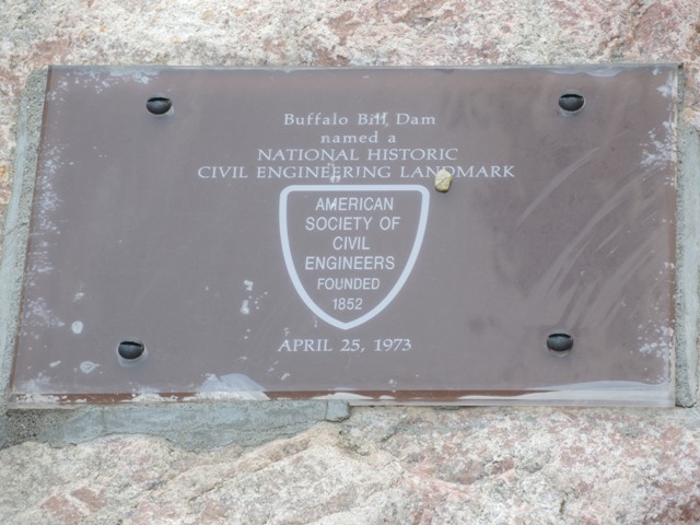
As we got close to Cody, we came upon the Buffalo Bill dam.
Steve couldn't get a decent picture of it. It was built in such a difficult place that the American Society of Civil Engineers designated it a National Historic Civil Engineering Landmark.
Then we headed for Southfork B&B, where we have terrific Internet access and I'm managing to upload pictures without it taking forever. Yeah!
Sunday morning we got up for a home made breakfast at 8. It was worth it. Scrambled eggs, home made sausage, hash browns, home made biscuits and strawberries. The owner is a former chef. We ate too much. All this eating out is going to show up on the scales when we get home.
We then headed for the Buffalo Bill Center of the West. It's really about 5 museums in one. One wing is, of course, devoted to Buffalo Bill. But there's also a wing devoted to the Plains Indians, a Whitney Western Art Museum, the Cody Firearms Museum and the Draper Natural History Museum. Huge place and very interesting.
Buffalo Bill was the rock star of his day. He took his wild west show all over the world. He even did a command performance for Queen Victoria. But before his show business days, he hunted buffalo for the railroad and the army to feed the workers. He also worked for the pony express, for a month or two during it's 18 month existence. Any longer would have killed him he said, as it was a dangerous and exhausting job. He then became a scout for the army. His knowledge of the West was real.
A lot of the art was very good, but expected subject matter. There must have been 10 different paintings of the lower falls of the Grand Canyon of Yellowstone. But there were several unique pieces. Steve and I each took a picture of this piece. The plaque beside it said something along the lines of ".. a traditional subject with a modern twist."
I don't know if you can tell, but the modern twist is that it's painted like a paint by numbers painting, except for the shadow.
One unexpected offering was a raptor show. The Center has a few birds that have been injured and cannot be released to the wild. We saw a turkey vulture, a red tailed hawk, a horned owl, and my favorite, a golden eagle.
Tomorrow morning it's another home made breakfast (at 8 am) and then we are headed for Custer, South Dakota. Steve made some planning errors and we have a 7 - 9 hour drive tomorrow. We'll be tired after that long day and probably won't have much to report, so I may not blog again until Tuesday.
Friday, August 9, 2013
Friday, August 9, 2013, Last day in Yellowstone.
I was going to update yesterday's post first, but today was pretty interesting so I'll do it first. But if the internet connection holds up, I'll go back and update yesterday's entry. (I'm assuming someone is actually reading this.)
Yellowstone was the first national park in the world, so it's our oldest and I think one of our biggest. The road system is a large figure 8 with 5 roads leading away from the 8 to outside the park. We're staying at a cabin a Canyon Village, which is about at the middle of the 8. Yesterday we did the southern loop, which included Old Faithful, so today was the day for the nothern loop. You can see maps and things at www.nps.gov/yell.
Steve had a nice chat with a ranger when we first entered the park and we've been following his suggestions. So today we headed toward Roosevelt Lodge, stopping to look at Washburn Hot Springs.
This hot spring area is so unstable that they have given up trying to make it accessible. This is as close as you can get. They warn you about this all the time, but today Steve saw two people step off the path to touch the water. Twelve people have lost their lives doing that and hundreds have been seriously injured over the years.
Yellowstone is continually battling forest fires, some worse than others. In 1988, 36% of the park burned. I've tried to enhance the photo below to show what a burned out hillside looks like.
The far hillside is gray with tree skeletons. Closer at hand, you see a green forest fading to gray. The
gray is what burned. As you travel through Yellowstone, lots of mountainsides have two or three shades of trees. The young ones are lighter green and shorter and they may be growing next to a taller tree area that has even taller trees beyond it. The youngest trees are growing on the most recently burned areas. Throughout the shorter trees you see the skeletons of burned trees standing. My guess is that most of Yellowstone has burned at one time or another in the last 50 years.
We continue on to Roosevelt Lodge and go through some roadbuilding, which focuses us on some unique geology.
This undulating stone is not from the contruction work, as I spot the same seam across the canyon.
We reach Roosevelt Lodge, which is very rustic and small, (but does have real bathrooms) and, taking our ranger's advice, take the road leading out of the park through the Lamar Valley. We're only supposed to take it for about 10 miles and then come back and finish the northern loop. But it should be good for spotting wild life.
The way you spot wildlife in Yellowstone is to watch for people pulled over. We saw a couple of cars pulled over that were watching something we couldn't see with the naked eye, but then, at the top of a rise in a wooded patch, a man had set up a telescope focused on an osprey nest. And there were chicks, which aren't so small by this time. Here's the nest:
We traveled on, seeing a single bison or two, and then there's a small herd. And then there is an entire valley filled with bison. We have so many buffalo pictures it's hard to pick just a few. There are way more buffalo than yesterday.
After seeing hundreds of buffalo spread across this valley, we turn around to continue on the northern loop. All along the way, we see people flyfishing and some hiking. There seem to be hundreds of hikes in this park. Back on the northern loop, we are headed for Mammoth Hot Springs, one of the places the ranger said to see. It's also a small town with the park headquarters and as it turns out, is packed. Did I say Yellowstone was a bit crowded? And we've missed high tourist season of July.
Before we hit Mammoth Hot Springs, we stop to see a petrified tree. It turns out to be interesting. It's just a stump, 6 foot tall or so, but it's genetically identical to California Redwoods and was petrified in an erruption 50 million years ago. It's taking too long to load photos to include one here. I'm sure there's one on the web if you google it. We also stop and take a picture of Undine Falls before entering Mammoth Hot Springs. Here is the hot spring it's named after.
That whole mountain side is covered with hot springs. The mineral deposits expand the mountain at the rate of about 3 feet a year. They keep having to move the trails to the viewing areas. It is indeed Mammoth.
It looks like I'm having trouble uploading photos today, too. They will be added as soon as we have better connections.
We take a loop road to look at the top of Mammoth Hot Springs and get some interesting shots.
This area is outside of the volcano caldera, so the activity is surprising but things keep changing. Once off the loop road we drive up into a high valley and spot some brown birds we're not familiar with. They look like herons, but are not blue. I'll get a picture up when I can.
There is a side road to something called the Virginia Cascade that we decide to take. I'm guessing we're going to see a series of small waterfalls and we do. I'll add a picture when I can.
But the surprise lies ahead.
There is a bison walking down the road toward us. Calmly, like he owns the place, (he does), he heads for us. Steve is taking pictures with his camera out the window. We are stopped. He contiues to walk toward us and walks right by, about 3 feet from Steve, who does not try and touch him. We have had a buffalo encounter! I hope this picture loads!
Well that's enough excitement for the day. We contiune back to Canyon Lodge and our cabin, stopping to pick up a salad and a sandwich for dinner. Pulling up to our cabin, I notice people beside it with their cameras out. We have deer in our back yard!
A great end to a great day!
Now if I could just get more pictures posted!
I managed a few, but it's like pulling teeth, so I'm off for now. We should be back in civilizaion tomorrow, so maybe we'll have more luck.
I was going to update yesterday's post first, but today was pretty interesting so I'll do it first. But if the internet connection holds up, I'll go back and update yesterday's entry. (I'm assuming someone is actually reading this.)
Yellowstone was the first national park in the world, so it's our oldest and I think one of our biggest. The road system is a large figure 8 with 5 roads leading away from the 8 to outside the park. We're staying at a cabin a Canyon Village, which is about at the middle of the 8. Yesterday we did the southern loop, which included Old Faithful, so today was the day for the nothern loop. You can see maps and things at www.nps.gov/yell.
Steve had a nice chat with a ranger when we first entered the park and we've been following his suggestions. So today we headed toward Roosevelt Lodge, stopping to look at Washburn Hot Springs.
This hot spring area is so unstable that they have given up trying to make it accessible. This is as close as you can get. They warn you about this all the time, but today Steve saw two people step off the path to touch the water. Twelve people have lost their lives doing that and hundreds have been seriously injured over the years.
Yellowstone is continually battling forest fires, some worse than others. In 1988, 36% of the park burned. I've tried to enhance the photo below to show what a burned out hillside looks like.
The far hillside is gray with tree skeletons. Closer at hand, you see a green forest fading to gray. The
gray is what burned. As you travel through Yellowstone, lots of mountainsides have two or three shades of trees. The young ones are lighter green and shorter and they may be growing next to a taller tree area that has even taller trees beyond it. The youngest trees are growing on the most recently burned areas. Throughout the shorter trees you see the skeletons of burned trees standing. My guess is that most of Yellowstone has burned at one time or another in the last 50 years.
We continue on to Roosevelt Lodge and go through some roadbuilding, which focuses us on some unique geology.
This undulating stone is not from the contruction work, as I spot the same seam across the canyon.
We reach Roosevelt Lodge, which is very rustic and small, (but does have real bathrooms) and, taking our ranger's advice, take the road leading out of the park through the Lamar Valley. We're only supposed to take it for about 10 miles and then come back and finish the northern loop. But it should be good for spotting wild life.
The way you spot wildlife in Yellowstone is to watch for people pulled over. We saw a couple of cars pulled over that were watching something we couldn't see with the naked eye, but then, at the top of a rise in a wooded patch, a man had set up a telescope focused on an osprey nest. And there were chicks, which aren't so small by this time. Here's the nest:
We traveled on, seeing a single bison or two, and then there's a small herd. And then there is an entire valley filled with bison. We have so many buffalo pictures it's hard to pick just a few. There are way more buffalo than yesterday.
After seeing hundreds of buffalo spread across this valley, we turn around to continue on the northern loop. All along the way, we see people flyfishing and some hiking. There seem to be hundreds of hikes in this park. Back on the northern loop, we are headed for Mammoth Hot Springs, one of the places the ranger said to see. It's also a small town with the park headquarters and as it turns out, is packed. Did I say Yellowstone was a bit crowded? And we've missed high tourist season of July.
Before we hit Mammoth Hot Springs, we stop to see a petrified tree. It turns out to be interesting. It's just a stump, 6 foot tall or so, but it's genetically identical to California Redwoods and was petrified in an erruption 50 million years ago. It's taking too long to load photos to include one here. I'm sure there's one on the web if you google it. We also stop and take a picture of Undine Falls before entering Mammoth Hot Springs. Here is the hot spring it's named after.
That whole mountain side is covered with hot springs. The mineral deposits expand the mountain at the rate of about 3 feet a year. They keep having to move the trails to the viewing areas. It is indeed Mammoth.
It looks like I'm having trouble uploading photos today, too. They will be added as soon as we have better connections.
We take a loop road to look at the top of Mammoth Hot Springs and get some interesting shots.
This area is outside of the volcano caldera, so the activity is surprising but things keep changing. Once off the loop road we drive up into a high valley and spot some brown birds we're not familiar with. They look like herons, but are not blue. I'll get a picture up when I can.
There is a side road to something called the Virginia Cascade that we decide to take. I'm guessing we're going to see a series of small waterfalls and we do. I'll add a picture when I can.
But the surprise lies ahead.
There is a bison walking down the road toward us. Calmly, like he owns the place, (he does), he heads for us. Steve is taking pictures with his camera out the window. We are stopped. He contiues to walk toward us and walks right by, about 3 feet from Steve, who does not try and touch him. We have had a buffalo encounter! I hope this picture loads!
Well that's enough excitement for the day. We contiune back to Canyon Lodge and our cabin, stopping to pick up a salad and a sandwich for dinner. Pulling up to our cabin, I notice people beside it with their cameras out. We have deer in our back yard!
A great end to a great day!
Now if I could just get more pictures posted!
I managed a few, but it's like pulling teeth, so I'm off for now. We should be back in civilizaion tomorrow, so maybe we'll have more luck.
Thursday, August 8, 2013
Thursday, August 8, 2013 Yellowstone National Park.
Wednesday we moved from Grand Teton National Park to Yellowstone National Park. Although these parks are next door to each other, they are totally different. Grand Teton is a flat valley bordered by these immense craggy mountains on one side and Yellowstone is an active volcano. Yes, I said active. All the geothermal activity shown by the geysers, mud pots, vents and pools is part of a volcano. The park is really a large caldera (volcano bowl). Yellowstone is also mostly covered in lodge pole pines.
It's really amazing. This morning we started at the south rim of the Grand Canyon of Yellowstone. Assuming Steve gets the camera to cooperate, I'll add pictures. My computer has decided it doesn't like the chip from Steve's camera. Here's our current computer set up. Steve has his phone hanging from the light fixture and a cable to my computer. We're hooked up through AT&T
Wednesday we moved from Grand Teton National Park to Yellowstone National Park. Although these parks are next door to each other, they are totally different. Grand Teton is a flat valley bordered by these immense craggy mountains on one side and Yellowstone is an active volcano. Yes, I said active. All the geothermal activity shown by the geysers, mud pots, vents and pools is part of a volcano. The park is really a large caldera (volcano bowl). Yellowstone is also mostly covered in lodge pole pines.
It's really amazing. This morning we started at the south rim of the Grand Canyon of Yellowstone. Assuming Steve gets the camera to cooperate, I'll add pictures. My computer has decided it doesn't like the chip from Steve's camera. Here's our current computer set up. Steve has his phone hanging from the light fixture and a cable to my computer. We're hooked up through AT&T
The south rim of the canyon has Artist Point, which is a view back up the canyon to a water fall. You may have seen it in anything that references Yellowstone. I'll add a picture when I can.
We keep running into silver Prius and once again found ourselves parked by one.
I've gotten used to looking for a silver prius instead of a blue one. I wonder how long it will take me to switch back?
Loading photos is taking forever tonight, so I'll try to get a few up but not many.
Since Yellowstone is an active volcano, this area experiences frequent earthquakes. The ranger Steve spoke to said the earthquakes "change the underground plumbing" and things that were active become still and vice versa. One of the geysers recently erupted after 8 years and they have no idea when it might erupt again. Which is why Old Faithful is so amazing. It erupts every 40 - 100 minutes. We got to see it right after lunch.
We saw a few elk today, but today belonged to the bison (or buffalo). Traffic was stopped on the road and there was a small meadow with 5 or 6 bison, so Steve got out and took a few pictures. But it was obvious there was a greater attraction just over the hill. So I got behind the wheel to move up as we inched forward and Steve headed for the top of the hill on the other side of the road where 6 or 8 people were. Whatever he saw absorbed his whole attention and he did not notice that one of the bison was also climbing the hill. I can't yell, he can't hear me, chances are good the cell phones won't work, but luckily one of the other people there realized he didn't know what was going on and
got his attention.
got his attention.
He did get a good shot of that bison. What was capturing his attention on the other side of the hill was an entire valley of bison. We saw two more valleys of bison and a few close ups of some trying to cross the road. I'll come back and add photos when it won't take all night.
Well, we're having connection issues, so I'll sign off. More later
Tuesday, August 6, 2013
Tuesday, August 6, 2013 Float trip
We are up at the lodge by 8:45 am and they pile us on a bus at 9. We drive over to the Snake River 10 minutes away. Here's our float raft.
There will be 20 guests and two river guides on the trip and we end with lunch by the river.
This will be our scenery for the entire trip. We see beaver dams.
And blue heron.
And two eagles.
One mule deer.
Also canadian geese and chipmunks, but I won't include pictures. There are two different groups horseback riding along the river. It would be a beautiful place for that.
After two and a half hours of floating, we reach our lunch destination. And this is my view while I eat.
Tomorrow we head for Yellowstone. It's directly north of here, but will take close to three hours to drive to the lodge we are staying in. Time to get organized and packed up.
We are up at the lodge by 8:45 am and they pile us on a bus at 9. We drive over to the Snake River 10 minutes away. Here's our float raft.
There will be 20 guests and two river guides on the trip and we end with lunch by the river.
This will be our scenery for the entire trip. We see beaver dams.
And blue heron.
And two eagles.
One mule deer.
Also canadian geese and chipmunks, but I won't include pictures. There are two different groups horseback riding along the river. It would be a beautiful place for that.
After two and a half hours of floating, we reach our lunch destination. And this is my view while I eat.
Tomorrow we head for Yellowstone. It's directly north of here, but will take close to three hours to drive to the lodge we are staying in. Time to get organized and packed up.
Monday, August 5, 2013
Reasons for having an RV: no packing and unpacking, our own pillows, better lighting, nightstands on either side of the bed, a refrigerator for leftovers and breakfasts, and we'll each have our own desk.
Steve is hogging the tiny table and I'm blogging typing on a pile of pillows.
I'm reaching back to Saturday to get all our exploits in. Steve went on two additional adventures on Saturday. He visited EBR1 - Experimental Breeder Reactor 1. It was the first electricity generating power plant and was decommissioned in 1964. It's part of the Idaho National Laboratory. Wikipedia has a nice page on it.
After that, he headed back to Craters of the Moon to take a 3 hour evening hike, starting at 7 pm. He was hoping to take pictures of stars, but the hike ended before it was really dark enough. He did get a picture of a night blooming flower.
Reasons for having an RV: no packing and unpacking, our own pillows, better lighting, nightstands on either side of the bed, a refrigerator for leftovers and breakfasts, and we'll each have our own desk.
Steve is hogging the tiny table and I'm blogging typing on a pile of pillows.
I'm reaching back to Saturday to get all our exploits in. Steve went on two additional adventures on Saturday. He visited EBR1 - Experimental Breeder Reactor 1. It was the first electricity generating power plant and was decommissioned in 1964. It's part of the Idaho National Laboratory. Wikipedia has a nice page on it.
After that, he headed back to Craters of the Moon to take a 3 hour evening hike, starting at 7 pm. He was hoping to take pictures of stars, but the hike ended before it was really dark enough. He did get a picture of a night blooming flower.
On a two and a half week trip, you either pack a lot of luggage or you do laundry. We usually choose laundry. So Sunday was a designated laundry day. We had checked on line and there was a laudromat in Arco, Idaho. We even drove by and checked their hours - 8 am to 8 pm 7 days a week. Good to go. So bright and early Sunday we have breakfast, load up the car and head for the laudromat. We go in and Steve notes there is no detergent or change available. He heads for the gas station/convenience store next door and I load up washers.
Time for plan B. No detergent available. Unload the washers, pack up the car, and head for Idaho Falls. Steve decides we should stop at the first grocery store we see in Idaho Falls and pick up detergent and a few extra items we need. He pulls in at an Albertson's and parks in front of the laundromat next door. Bingo! He gets the laundry out while I run into Albertson's.
The washers are tiny. We have three loads. The instructions want you to put powder detergent in one container at the beginning of a cycle or liquid in a different spot after the first rinse. I bought pods good for a single load. No place to put them. Steve decides he'll watch the loads and put the pods in appropriately. There are signs around telling us not to use extra detergent as the water is soft. Can you see where this is going? Yup, had to send each load through an entire second cycle to get all the soap out.
Once we get everything in the dryer, Steve has me check on restaurants for lunch. Urban Spoon (iPhone app) says there's a good mexican place at the end of the strip mall. Yeah. Only it's closed on Sunday. We pass another restaurant closed on Sunday and I'm beginning to worry. But the next recommendation from Urban Spoon, Smitty's, is open and doing a good business. We have a good lunch. By the way, in this part of the country, one of the sides available is tater tots, as in "Do you want chips, fries, or tots with that?"
Then it's on to Grand Teton National Park in Wyoming. I swear the scenery changes by state. California was fertile fields followed by pine forested mountains. When the pine forests changed to desert, we were in Nevada. When irrigated farming started (and casinos stopped) we were in Idaho. For the last bit of Idaho, irrigation wasn't required, but they were looking hard for flat spaces to farm. When we ran out of farmland and were back in pine forested mountains, we had entered Wyoming.
I've heard of Jackson Hole, usually in terms of skiing. Turns out hole is a term for valley, so this is the Jackson Valley, one side of which is the Grand Tetons. There is a town called Jackson and a Jackson Hole ski resort. Both of which seem very touristy. Jeremy, Marilyn and John, this area reminds me of New Zealand. Even part of the Snake River here looks like the braided rivers there. And Jackson reminds me of Queensland. Too many tourists, too many shops. The antler arches are different, though.
We saw a number of these. But this is what we came for:
a bear and her cub
Monday morning, Steve is awake early (5 am-ish) and heads out to take sunrise pictures. Blessedly he lets me sleep.
He manages to catch the sunrise and some mule deer.
And this bird. He got the name of it from a park ranger later, but he's now asleep, so I'll pass that information along later. But it's a neat photo.
I'm awake by the time Steve returns. He has plans to hike at Jenny Lake today. Sounds doable. We walk up to the Lodge for breakfast; we're staying in a "cabin" - motel like unit. The walk up to the lodge and back tires me out and I realize that my cold needs more sleep. I urge Steve to go hiking and am almost asleep bfore the door closes. I really did need the sleep; I sleep all day.
Steve has a great day and take lots of pictures. Unfortunately, some of them don't want to transfer to my computer. But here's some of what he saw:
Jackson Lake
Jenny Lake
The chapel was built before the land became National Park Land. The park was established in the early 1920's consisting of only the actual mountains. When John D. Rockefeller, Jr. visited around 1926, he realized that more area needed to be preserved and started buying up land. He tried for 20 years to get the government to accept the land as a gift. In the meantime, he built lodges and other items needed and established the company that runs the lodges today. In the 50's, the government finally accepted all this land into the national park.
Tomorrow we're going to try a float trip!
Subscribe to:
Posts (Atom)


small.jpg)