Friday, July 31, 2015

Friday, July 31, 2015

We are in Hinton, Alberta, Canada.

We left Charlie Lake, BC, after saying goodbye to Obi.  Our first stop was the Kiskatinaw Bridge, which was built during the original construction of the Alaska Highway.  It was one of many engineering feats during construction.  It’s a curved timber bridge.  I think it’s the only original bridge still in use.  It’s no longer on the Alaska Highway, which by passes it, but is used by local traffic.


Dawson Creek, BC, the start of the Alaska Highway, was our next stop.  (We managed to do the highway backwards of course.)


They have a nice sculpture of a surveyor on the actual mile zero spot.


We’ve purchased one of the videos that documents the building of the highway, but there are several available.  They are well worth watching if you can find one on Netflix or Amazon.  They planned and built the highway through the wilderness in 8 months under horrific conditions in a climate they didn’t understand.  And it’s still a major artery today, although it doesn’t carry nearly as much traffic as we expected.  It’s hard to imagine how immense and sparse this area is.

The land changed shortly before we reached Dawson Creek.  We were now in farmland, not forest and there were actual planted fields and fences, something we haven’t seen much of since leaving Washington state.  Temporarily at least we were on the prairie.  Which was fitting, since we spent that night in Grand Prairie.

Grand Prairie’s population is about 55,000. But we weren’t ready for the traffic!  We really hadn’t seen much traffic since Anchorage, and it wasn’t this bad.  Luckily, we just cut across a corner of the city on our way to our campground south of town.  We were there just one night and then headed for Jasper National Park. 

All the park campgrounds were booked for the August long holiday that Canada has.  So we’re parked at a KOA between the park and Hinton, AB.  Steve was anxious to get to the park, so after we got the trailer set up, we headed in.

And right away, got our first animal shot, actually 2.  First, an elk who obviously had no fear of the humans or cars right next to the road.


And right across the road, two goats, who weren’t sure about this.


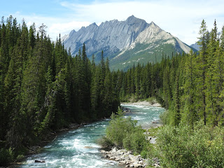
The scenery in this park is stunning.  Here are some pictures we took yesterday.


Today, we headed back into the park, and again our first stop was for wildlife.  Goats again.


 Our next stop was Maligne Lake, a glacial lake in the mountains.  We took a boat ride to the far end of the lake to view several of the glaciers not viewable any other way.  Here are some pictures from the trip.


Sometimes the scenery doesn’t look real.  This shot is from Spirit Island at the far end of the lake.


Back at the dock, we had lunch at the cafĂ© there and enjoyed more of the scenery. 


Back in 1928, Curly Phillips decided he liked this place and wanted to run a fishing business here.  Only there were no fish in the lake.  No problem.  He imported fingerlings (baby fish) and stocked the lake with rainbow trout.  He built a boathouse that still functions today.


Curly lived in the boathouse until his death.  You can see why he chose this spot.

We left Maligne Lake and headed for Maligne Canyon, stopping at a few vantage points along the way.

A mountain stream.


Medicine Lake.

Steve hiked part of trail along Maligne Canyon, which is mostly a narrow, slot canyon.


As a result the water rushes through.


By then it was time to head for home.  But we did have one more wildlife viewing – another elk beside the road.


There’s really no way to describe this scenery and the photos don’t really do it justice.  If you ever get a chance to get up this way, grab it.

Deb


Tuesday, July 28, 2015

Tuesday, July 28, 2015

We are at Charlie Lake, British Columbia, just outside Fort St. John.

It’s been a rough 48 hours.  Obi woke me Sunday night at 11:30 to go out, not unusual, but not common.  He went out and did his duty and we came back in, but he couldn’t get settled.  He was whining and crying.  He and I ended up on the couch all night.

We were in Fort Liard, Northwest Territories.  The internet said Fort Nelson, back on the Alaska highway, had a vet.  It was 3 hours away.  I let Steve sleep, figuring one of us needed to, so that he could drive.  He got up at 5:00 a.m. to check on us and we were on our way by 6:00.  By 9:00, we had reached the Chamber of Commerce in Fort Nelson, only to find out that the nearest clinic was actually in Fort St. John, another 4 hours away, not counting construction and pulling the trailer.

We were finally able to phone the clinic around 2:00 p.m.  They had an open appointment at 4:30, but would work us in as soon as we arrived, which we anticipated would be 3:30.  Obi was still obviously in a lot of pain.  I made him as comfortable as I could on my lap.

He was dehydrated and his digestive tract was blocked.  They wanted to keep him overnight and get some fluids into him.  They gave him some pain killers to make him as comfortable as possible.

Unfortunately, this morning there was not good news.  He had pancreatitis and needed to have his gall bladder removed, assuming they could get him healthy enough to have surgery.  We were reasonably sure with his diabetes and other health issues, that he wouldn’t survive the surgery and the vet agreed.  So we hugged him and loved him and let him go.

Rest in peace, Obi.


Sunday, July 26, 2015

Sunday, July 26, 2015

We are at Hay Lake, Fort Liard, Northwest Territories.  This seems to be a popular local park with 12 campsites and no hook ups.  That means we are supplying our own electricity and water and we’ll have to dump our tanks at our next stop.  We’re using our propane for cooking and heating. It’s been a nice relaxing camp.

I didn’t expect to have Internet access, but thanks to all the mining companies around here, there is cell service so we have Internet. 

Here’s the view out my side window:


And the view out the back window.


 There’s a trail around the lake and apparently they don’t want people snowmobiling on it.

We are in the Northwest Territories of Canada and we mostly came up here to add another territory to our list.  It sounded like it would be a nice trip and was, except for the rain, but the scenery hasn’t been spectacular.  The sign welcoming us to the Northwest Territory:


 The bridge Steve said reminded him of one of the rides at Disney World:


But when we got to the campground and got settled in, the wildlife started making an appearance.  First (as always) came the ducks.


More ducks.


Then the swans from the end of the lake came close enough for some pictures.
But we couldn’t get all 5 in the same shot.


Non aquatic birds also made an appearance.  We think this might be a gyrfalcon.
And these birds played along the shore.
But we really got excited about the beaver, who was fetching twigs for his dam.


Neither picture is wonderful, but we had fun watching him.


We headed back to Fort Nelson tomorrow.  Then it’s on to Dawson Creek, where the Alaska Highway (formerly known as the Al-Can highway) officially starts/ends.  Luckily there are still highways beyond that to take us to Jasper and Banff.


Deb

Friday, July 24, 2015

Friday, July 24, 2015

We are in Fort Nelson, British Columbia, Canada.


It was an overcast, rainy day today, coupled with road construction.  I took a few scenic pictures.

Our last look at Muncho Lake:


A braided river
.

And then we saw the moose.  He was maybe 100 yards off the side of the road, content to pose for pictures for awhile.


We’ll probably be off the grid for the next two nights.  We’re headed up to Fort Liard in the Northwest Territory.  It’s supposed to be a beautiful spot.


Deb